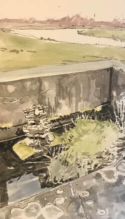
 | Some flood valves? in a concrete drainage tank in the meadow below Route 51 to Sandy, just beyond Priory Country Park. I'm not really sure what the tank is, nor did the pike fisherman I asked, but there are 4 or 5 in a row at intervals of about 100 yards alongside the disused railway track. Lichen grew on concrete and metal. Grass and reeds grew in the accumulated sludge collected in the bottom of the tank. It rained while I sketched, and the water reflected an overcast sky. Riverfield drive and its bordering trees mark the horizon. The crescent-shaped water is one of the lakes in a (1992?) nature reserve alongside the Great Ouse. The river beyond flows left to right down to Castle Lock. My arrival dispersed the grazing ducks, and the sound of a helicopter drove a wide V-formation Canada geese directly over my head. |
|
|
|
 RSS Feed